|
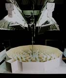
 Visibility of Guide Signs for Pedestrians in Motion: an application of an immersive visual simulation system Visibility of Guide Signs for Pedestrians in Motion: an application of an immersive visual simulation system
|
|
<Presented at 9th European Architectural Endoscopy Association Conference8,
Cottbus, Germany, 2009 >
|
| Ryuzo Ohno and Yohei Wada |
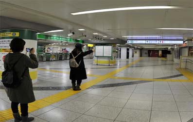
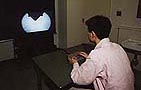
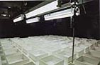
| When we visit a complex public space such as a railway station or a large
shopping mall for the first time, we must rely on guide signs to find our
way. In crowded situations, we are called upon to read these signs while
walking so as not to disturb pedestrian flow. The present study uses an
immersive visual simulation system to examine the influence of observation
conditions on sign detection and recognition. The experimental variables
address the spatial layout of signs as well as the presence of other pedestrians.
The results indicate some quantitative relationships between the above
variables and readability and suggest effective layouts for signs in spaces
where crowded conditions are unavoidable. |
|
| Full paper → PDF (DUMS2012) |
|
|
The effect of the configuration and the interior design of a virtual weightless space station on human spatial orientation
|
|
<Acta Astronautica, No. 56, pp. 1005-1016, 2005>
Hirofumi Aoki, Ryuzo Ohno, Takao Yamaguchi
|
| Full paper → PDF |
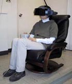
In a virtual weightless environment, subjects’ orientation skills
were studied to examine what kind of cognitive errors people make when
they moved through the interior space of virtual space stations and what
kind of visual information effectively decreases those errors. Subjects
wearing a head-mounted display moved from one end to the other end in space
station-like routes constructed of rectangular and cubical modules, and
did Pointing and Modeling tasks.
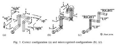
In Experiment 1, configurations of the routes were changed with such variables as
the number of bends, the number of embedding planes, and the number of planes with respect to the body posture.
The results indicated that spatial orientation ability was relevant to the variables and that orientation errors
were explained by two causes. One of these was that the place, the direction, and the sequence of turns were incorrect.
The other was that subjects did not recognize the rotation of the frame of reference, especially when they turned in
pitch direction rather than in yaw.
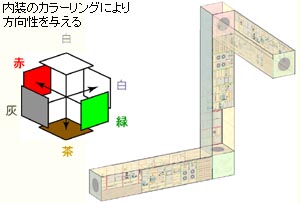
In Experiment 2, the effect of the interior design was examined by testing three design settings. Wall colors that showed the allocentric frame of reference and the different interior design of vertical and horizontal modules were effective; however, there was a limit to the effectiveness in complicated configurations. |
 |
| A Study of Orientation in a Zero Gravity Environment by means of Virtual Reality Simulation |
<Journal of Gravitational Physiology, Vol. 7, No. 2, pp. 93-94, 2000>
Hirofumi Aoki, Takao Yamaguchi, Ryuzo Ohno |
| This study intends to clarify how people acquire visual information and recognize their orientation in a zero gravity environment. An experiment was conducted using virtual reality.
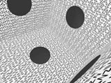
In Study 1, each subject was given tasks in which a subject moves through virtual reality from the central room into one of six rooms such as operation room and habitation room. Textures composed by alphabetical letters were stuck on the six surrounding surfaces of the central cubic room. Visual information of the cubic room and the degree-of-freedom of motion were varied, and the subjects’ performance was measured. To some extent, the experiment produced a subjective sense of weightlessness. Moreover, we identified different strategies of spatial cognition and behavior under conditions of virtual weightlessness.
In Study 2, subjects’ orientation skills were tested with pointing and orienting tasks. Subjects followed virtual routes that were constructed of three or four rectangular modules that were connected by the cubical modules. Each subject moved from one end to the other end, and pointed to the start point and reproduced the experienced route using a scale model. The shapes of the routes were changed systematically.
Analyses of the results indicate that the ability of special cognition changes with such variables as the number of comers of routes, the geometric number of fields and the number of fields with consideration to the body posture.
|
  |
 |
| Paper → PDF |
|
Effective
Visual Clue on Recovering Orientation in an Interior Space
|
|
<Proceedings of the 5th EBRA International Symposium for Environment-Behavior
Studies, Shanghai, China, 155-160, 2002>
|
| Masashi Soeda, Ryuzo Ohno |
|
|
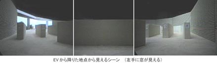
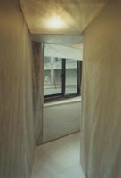
Our previous study revealed that people tended to lose orientation after such
vertical traveling as stairs, elevators and escalators, and that some of the
subjects could recover it by environmental information. Although the result
suggested that the source of information for recovering differed with person and
space, we could not specify effective information.
The present research intends to clarify influential visual information on recovering orientation using a visual simulator that enables a subject who wears a Head Mounted Display to walk through and to look around in a model space freely. Three settings of scale models of a two-story library were used in the experiment. In each setting, subjects were led from a start point on the first floor (information desk) to a destination on the second floor (a bookshelf) via elevator, and then they were asked to go back to the start point by themselves. In order to provide a possible visual clue for the subjects to find the start point, the scene that the subjects saw when they get off the elevator on the first floor was differentiated with left and right side by the following conditions: A) windows, B) walls with different colors (no windows), C) walls with same colors and same finishing (no differentiation). 46 graduate students were enrolled in the experiment.
The results indicates that more than 90% of the subjects could find the start point in the setting with windows, whereas 60% of the subjects succeeded in the setting with walls with different colors and less than 50% did in setting with no differentiated visual information. The interview conducted after the experiment reveals that more than 90% of the subjects used the windows to identify where the start point is, however, less than 60% used different colors on the wall. It also shows that almost all the subjects who did not use visual information mentioned above failed to find the start point. These results show that visual information provided by spatial elements helps people to recover orientation in the space, and that the windows are more effective for recovering orientation than changes of colors on walls are. The cause is considered to be the different characteristics of the visual information. Windows give spatial expansion, a view to outdoors and brightness to interior space. These characteristics of windows, which walls do not have, are considered to serve as an effective clue for orientation in an interior space. These results imply that it is important for legible interior space to arrange windows at the place where people tend to lose orientation.
Full paper → PDF (EBRA2002)
|
|
Adjustment of spatial orientation by visual information on walking on a pathway
|
|
<Summaries of Technical Paper of Annual Meeting of Architectural Institute
of Japan, Sep. 2001>
Kinuko Yamamoto, Masashi Soeda, Ryuzo Ohno
|
|
|
|
|
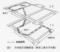
As a supplement to the former researches on wayfinding using the
visual simulator, the present study examines how actual body movement affect the
sense of orientation. A series of full-scale pathway was created to test how
sense of orientation is maintained after traversing multiple turns of various
angles. The results of experiment draw three conclusions: First, disorientation
occurred after multiple turns cannot be explained by accumulating each error
occurred after traversing single-turn. Second, sense of orientation can be
maintained by referring to such visual information as the clues to direction and
position in a space, and to the physical environmental features that help to
construct cognitive framework. Third, the ability of using the above information
for maintaining sense of orientation is varied among individual subjects.
|
|
The Influence of Staying and Moving Pedestrians in Wayfinding
|
|
<Summaries of Technical Paper of Annual Meeting of Architectural Institute
of Japan, Sep. 2000>
Akihiko Osawa, Hirofumi Aoki, Masashi Soeda, Ryuzo Ohno
|
|
|
|
|
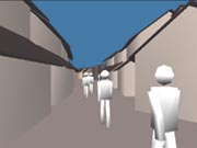
The
purpose of this study is to reveal the effects of pedestrians as movable
elements in wayfinding by a series of experiments using visual simulation
generated by computer graphics. The results showed that people on the street are
used as a clue for wayfinding., and that they have two functions. One is a
positive function that pedestrians provide an effective clue and help to
memorize a place where the subject exists. Another is a negative one that a
subject who memorizes a route depending only on existence of pedestrians loses
the way when they disappear and they play as a visual noise which disturbs
memorizing spatial characteristics.
|
|
What kinds of information do people utilize on wayfinding ?
|
|
<Proceedings of the 30th annual conference of the Environmental Design
Research Association, Pp.268, 1999.6>
Masashi Soeda, Ryuzo Ohno
|
|
|
| An experiment
was conducted to clarify what kinds of information people utilize on wayfinding
under several settings, in an actual interior space and also in a simulated
scale-model space. In both situations, subjects were lead to a room through a
corridor and were asked to do a sham task there, and then they were asked to
return the way they came. In each setting, the view from the doorway of the room
into the corridor was differentiated from the right to the left sides by
controlling such environmental elements as brightness, the ceiling height, depth
of the corridor, color of the wall and location of elemental objects (posters
and a plant).In actual full-scale
setting, while subjects were engaged in a sham task inside the room, the
environmental conditions of the corridor were changed. Upon exiting the room,
environmental elements had been moved in opposite locations. Subjects' behavior
just after leaving the room was noted and reasons for the route choice were
interviewed later.Results showed
that while most people rely on their memory to return, some people rely on
visual information on the spot. This also reveled that the redundancy of various
kinds of environmental information is essential for wayfinding.
|
|
Wayfinding
in Cases with Vertical Motion
|
|
<Proceedings of MERA 97: International Conference on Environment-Behavior Studies for 21st Century, Pp.559-564, 1997.11>
Masashi Soeda, Noriko Kushiyama, Ryuzo Ohno
|
|
|
|
|
This study intends to clarify the influence of vertical traveling
on spatial cognition and wayfinding performance. Wayfinding
experiments were conducted in campus buildings and a department store. A
pointing task was also conducted in another building in the campus. The result
shows that people tend to lose orientation after vertical traveling, but some
of them can recover it by environmental information, and that traveling from
one floor to another, people tend to assume the new floor plan depending on the
former plan. It also shows that the source of information for wayfinding differs
with person and space, successful subjects tend to get information not only from
such elemental features as objects and signs but also such ambient features as
direction and configuration of spaces.
Full paper ⇒PDF file
|
|
A study of wayfinding strategies using a visual simulator
|
|
<Architectural and urban simulation techniques in research and education
-Proceedings of 3rd EAEA conference-, Pp.87-92, 1997.8>
Masashi Soeda, Ryuzo Ohno
|
|
|
Paper ⇒PDF file |
|
This study investigates the relation between wayfinding
performance and the strategies which are expected to differ with individuals. Three scale models
(1/150) of an identical maze pattern each with different visual information were
used in the simulator which was designed to allow a subject to move through a
model space and visually experience a travel sequence. Three conditions of
visual information were : (1) no characteristics, with monotonous surfaces and
uniform width of streets, (2) variations in spatial arrangements, with changes
of street width and corner shapes, (3) symbolic information, provided by letters
and photos of newspaper on the walls. Each of three male and three female
subjects was first asked to memorize the route by viewing a predetermined
continuous sequence of model streets , as shown on the screen, and were then
asked to take the instructed route. This procedure was repeated until the
subject could reach the end of the route. After that, they were asked to draw a
cognitive map of the route. This series of experiment was conducted five times:
5, 12, 36, 128 days from the first experiment. On and after the second
experiment, the subjects were asked to explain the route verbally at the
beginning of the experiment. The result indicates that some people shift their
wayfinding strategies reasonably according to the visual information on the
route, and other people tend to rely on mainly one type of information to
memorize a route at any situation. It also showed that people can take the right
route by obtaining elemental information on the spot even if they have no clear
memory in advance.
|
|
Street-scape and Way-finding Performance
|
|
<Proceedings of the 2nd EAEA Conference, pp. 111-120, Sep. 1995>
|
| Ryuzo Ohno, Koichi Sonoda, Masashi Soeda |
 |
The hypothesis that way-finding performance depends on the visual
characteristics of the street-scape was investigated by an experiment using
a user-controlled space-sequence simulator which was designed to allow
a subject to move through a model space and visually experience a travel
sequence.
Three scale models (1/150) of an identical maze pattern each with a different
street-scape were used in the simulator. The three types of street-scapes
were: (1) no characteristics, with monotonous surfaces, (2) each corner
distinguished with a different building, and (3) streets furnished with
trees, columns or fences.
Each subject was first asked to memorize the route by viewing a predetermined continuous sequence of model streets, as shown on the screen, then asked to take the instructed route. This procedure was repeated until a subject successfully reached the end of the route. Subjects were allowed to try up to five times. After the experiment, the subjects were asked draw a cognitive map of the route. Three male and three female subjects were tested in each of three street types.
An analysis of the results generally supported the hypothesis that a route in streets with significant visual characteristics was easier to memorize, although there was a large difference in performance between subjects. With an analysis of the cognitive maps drawn by the subjects, it was noted that subjects seemed to rely more on incoming visual information on the changing scene than on structured knowledge of the route, as is emphasized in conventional theory of way-finding.
Paper -> PDF |
goto TOP
|